As the Hot Pot wildland fire in northern Nevada exploded at a pace of 10,000 acres per hour, a new mountaintop fire-spotting camera system built by the University of Nevada, Reno helped fire officials muster resources in a full-on response that began July 2.
"The situation awareness is a much higher payback with the cameras," said Paul Petersen, State Fire Management Officer for Nevada BLM Fire and Aviation. "We were able to relay our situation to the Great Basin Coordination Center in Salt Lake City and the National Interagency Coordination Center in Boise. By both of those centers watching the camera and having an overall situation picture, we were able to get five additional air tankers from Utah and Idaho and a DC-10 air tanker from California."
Traditionally, fire managers would send planes to spot and monitor fires, which takes time and resources. The fire cameras provide the possibility for faster and more efficient and effective response.
The Bureau of Land Management, in partnership with the University of Nevada, Reno funded five of the live-broadcast cameras on remote mountain peaks in central and northeastern Nevada last fire season using the University's private high-speed internet system capable of transmitting seismic, environmental and climate data, in addition to the live-streaming high-definition video from the fire cameras.
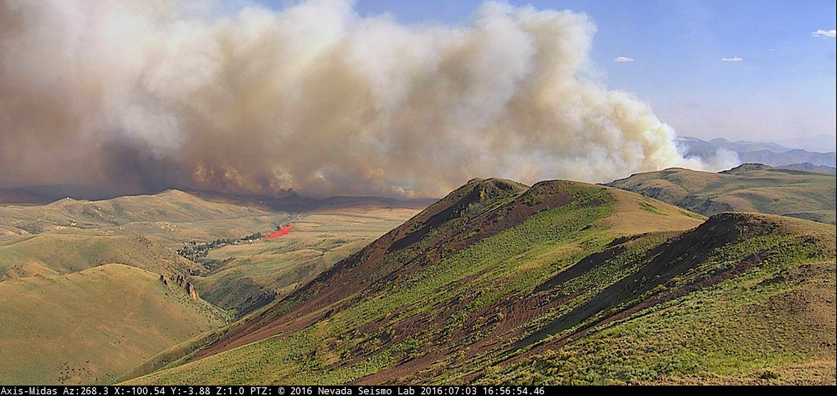
The Seismological Lab uses Axis new IR-capable HD cameras, with 32x, pan-tilt-zoom capability, providing 360-degree panoramic views from high mountain towers. The tower-mounted camera on the 7,800-foot-elevation Midas Peak, about 40 miles north of Battle Mountain, was used to monitor the fire.
"The system enables the fire coordinators to have a 'live view,' as if they were sitting on the mountaintop, directing resources," Graham Kent, director of the Nevada Seismological Laboratory, said. The fire camera system piggybacks on the Seismological Lab's earthquake monitoring system with its 150-plus seismographs throughout Nevada.
The Hot Pot fire was listed at 123,000 acres on July 5, with containment expected by July 9, just seven days after ignition, and is listed now as 80 percent. On July 2 the fire was burning at a rate of roughly 3 acres burned every second, 166 acres every minute and 10,000 acres every hour for a total of 56,000 acres in one continuous run.
"The cameras are strategically sited to provide a landscape overview," Petersen said. "All cameras are equipped with on-demand time-lapse functions to allow playback throughout different time periods. This allows dispatchers and duty officers to play back the camera feed to detect anomalies and gather a local picture of what is happening, and has happened, within the field of view of the camera. This camera network gives fire managers a real-time picture of what is happening from both a weather and fire behavior standpoint."
The other BLM-funded mountaintop cameras are on 10,000-foot-high Jacks Peak, between Elko and Owyhee; 10,187-foot Callaghan Peak, north of Austin near the Iowa Canyon Reservoir; and Fairview Peak, south of Highway 50 and about 30 miles southeast of Fallon near Sand Mountain. New BLM-funded stations are being installed during the next few weeks at Knoll Mountain north of Wells and Spruce Mountain in northeast Nevada, enabling even more landscape to be viewed this year and into the future. A new camera was just installed on Cave Mountain near the town of Ely.
The BLM system has been used successfully for one fire season for early detection, to spot and track fires and to provide quicker, cheaper and more tactical responses and suppression. The system has sufficient bandwidth and availability to support other emergency response scenarios, such as rapid set up of incident command stations within hours anywhere in the field with very high data transmission rates.
"The BLM system is an outgrowth of our AlertTahoe pilot program," Kent said. "We started three years ago with one camera, and then three cameras the following year around the rim of the Tahoe Basin, and now have 13 cameras successfully spotting and monitoring fires 24/7 in the Tahoe and Reno area."
One of AlertTahoe's newest cameras, just west of the Tahoe basin at Big Hill, was used in the initial stages to track the Trailhead fire burning 25 miles away near Foresthill, California. This year the lab has, so far, added another six cameras to their network bringing the total to 18, with plans to install more by fall of 2016.
"The cameras are not only for public safety but help protect local economies, whether through directly stopping larger fires from burning through a community causing economic hazard of the first order, or from smoke that can cause significant damage to economies downwind of the fire, such as the King Fire of 2014 in the Lake Tahoe region," Kent said.
The BLM already has a network of personnel who routinely tap into the system based on quick-views through the Seismological Lab's website. If a potential fire is recognized, they can take control of the camera and zoom to that location.
"We have almost 500 people looking at the public site at various times, and 12 duty officers and dispatchers have access to the cameras for tactical fire response 24/7," Petersen said.
Kent encourages the public to log on to the Seismological Lab's website to help scan for fires.
"The beauty of this system is that not only can fire service personnel look for indications of fire, but the public interface can be used by anyone, at any time, to look for fires in a crowd-sourcing fashion," Kent said. "The more eyes the better. While fire agencies can move the cameras with active pan-tilt-zoom functionality, the public can observe the real-time views as well as the time-lapse functions with a 15-minute, 60-minute, 6-hour and 12-hour time-lapse utility built into the webpage viewer or our YouTube channel."
The Nevada Seismological Lab, a public service department in the University's College of Science, is a member of the USGS Advanced National Seismic System and operates a network of about 150 real-time seismograph stations throughout Nevada providing earthquake information to Nevada citizens, the USGS and local and state officials.
Watch the Hot Spot Fire explode from Midas Peak on YouTube
Situational awareness is key. Watch as the Midas Camera helps orchestrate retardant dumps near the old mining town of Midas within the tree-choked river valley.


