Update: The AlertTahoe camera network successfully played a role in the discovering and monitoring several wildland fires in the Lake Tahoe Basin and northcentral Nevada. These fires were sparked by lightening in the final days of June 2015.
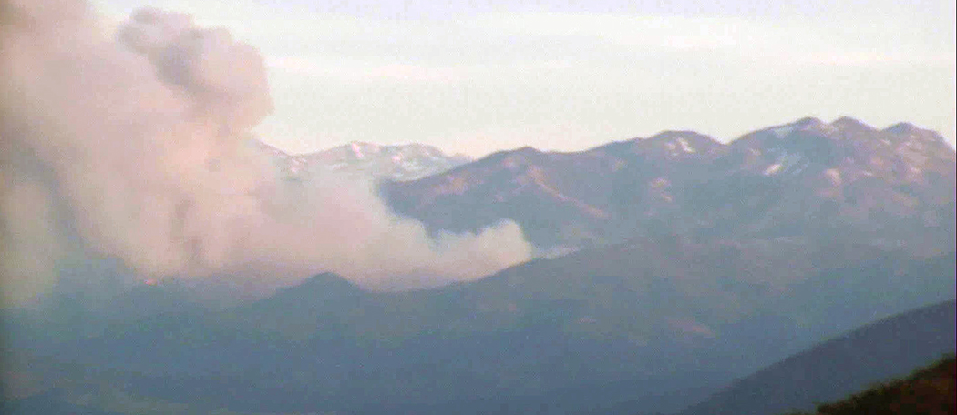
The AlertTahoe fire-spotting camera network is tracking the Washington Fire south of Lake Tahoe with two of its mountaintop cameras. The first wisps of smoke from the fire were seen on the cameras at 3:50 p.m. on Friday, June 19, one hour before the smoke was reported to fire officials. The fire is now more than 17,500 acres and 5 percent contained with a plume of smoke that extends more than 50 miles to the northeast and has covered parts of northern Nevada with blanket of haze.
"This really points to the importance of crowd-sourcing and/or artificial intelligence monitoring of the camera network," Graham Kent, director of the Nevada Seismological Laboratory, said. Two years ago he envisioned, and with his team of scientists, built and now maintains the expanding camera network. The nascent camera network piggybacks on the University's seismic monitoring system that spans Nevada and eastern California.
"Right now we have a private network for fire agencies to use, and, due to heavy usage, we're tweaking the public interface to allow people to more easily view the broadcasts and look for and report smoke," he said.
The fire agencies used the camera network to confirm the initial reports of the Washington Fire, and then were able to save time and resources by skipping a step to deploy resources more quickly.
The network features private high-speed Internet connectivity capable of transmitting seismic, environmental and climate data in addition to the live-streaming high-definition cameras.
"Had there been some crowd-sourcing, with enough volunteers monitoring cameras, as this weekend was forecast to be bad, maybe we could have picked off the ignition one hour earlier," he said.
Kent and his team's vision is to help firefighters respond to fires as soon as possible so the emergency responders can get a jump on the fire before it gets established and out of control, as happened last August in the Tahoe basin where the camera system helped spot a fire near Spooner Summit. The fire was knocked down before reaching half an acre. He envisions people connecting to the AlertTahoe website, using the time-lapse on demand feature so they can spot smoke early, as well as using specialized software to track smoke.
"The public can see the camera views now," Kent said. "Progress of the fire can be watched with our new (beta-version) on-demand time lapse."
Kent suggests using Chrome (PC) or Chrome/Safari (Mac) and "right-click" to get 15-minute, one-hour, six-hour and 12-hour options. A fast connection is useful, though the public site is limited to a few hundred, maybe a thousand, people until it is on the Cloud.
Thousands of public users are already monitoring the Washington Fire, which is stressing the public system-highlighting the need to host the AlertTahoe website in the Cloud for scalability.
Several fire agencies are using the small, and growing, network of cameras. While the cameras operate 24/7, the system to monitor the broadcasts is just beginning.
"This is why it's an all-in strategy," he said. "A comprehensive approach is needed - with the hi-tech cameras and imagery available to all the incident command centers, including at the scene; crowd sourcing of cameras with on demand time-lapse so people can easily report suspicious smoke; and machine-vision artificial intelligence interfaces," Kent said. "The AI is at the beginning of development, and crowd-sourcing is being planned, and for now they can confidently follow this fire."
After the first reports of the Washington Fire, the system's Snow Valley Peak camera was turned towards the fire and the McClellan Peak camera, just north of Carson City, was zoomed-in to better watch the progress of the fire and the smoke. The cameras can be manipulated by fire personnel to zoom, pan and tilt to get 360 degree views from the mountaintops.
The cameras are switched to infrared mode as the sun goes down so the fire can be tracked throughout the night.
The HD infrared-capable cameras are at the four corners of Lake Tahoe and 7,500-foot McClellan Peak north of Carson outside the Tahoe Basin to help fire agencies monitor and respond quickly to wildland fires, with the goal of saving the Tahoe Basin and northern Nevada from catastrophic fires. Cameras will soon provide coverage from 8,269-foot Peavine Peak, a location near the Desert Research Institute and in the Tahoe area from the Sierra-at-Tahoe ski resort and Big Hill on the western slope of the Sierra.
The expanded system is now helping to protect Nevada's forests and rangeland from devastating fires with the first four cameras, in collaboration with the Bureau of Land Management, overlooking several locations in north-central Nevada, and several more in the works.
"The fire cameras, and especially the Internet backbone and network that supports it, are a valuable tool for fire officials as well as researchers who are studying the Lake Tahoe and Great Basin environment," Kent said. "Fire agencies have been monitoring the region with our cameras for more than a year now, for both fire spotting and monitoring controlled burns."
"This new network can support critically important activities such as rapid set-up of incident command stations within hours anywhere in the field with very high data rates," Kent said. "Since this a private network, it is not susceptible to increased public Internet traffic following high-impact catastrophic events - earthquakes, floods and fires."
The Nevada Seismological Laboratory is a public service department in the University's College of Science.


