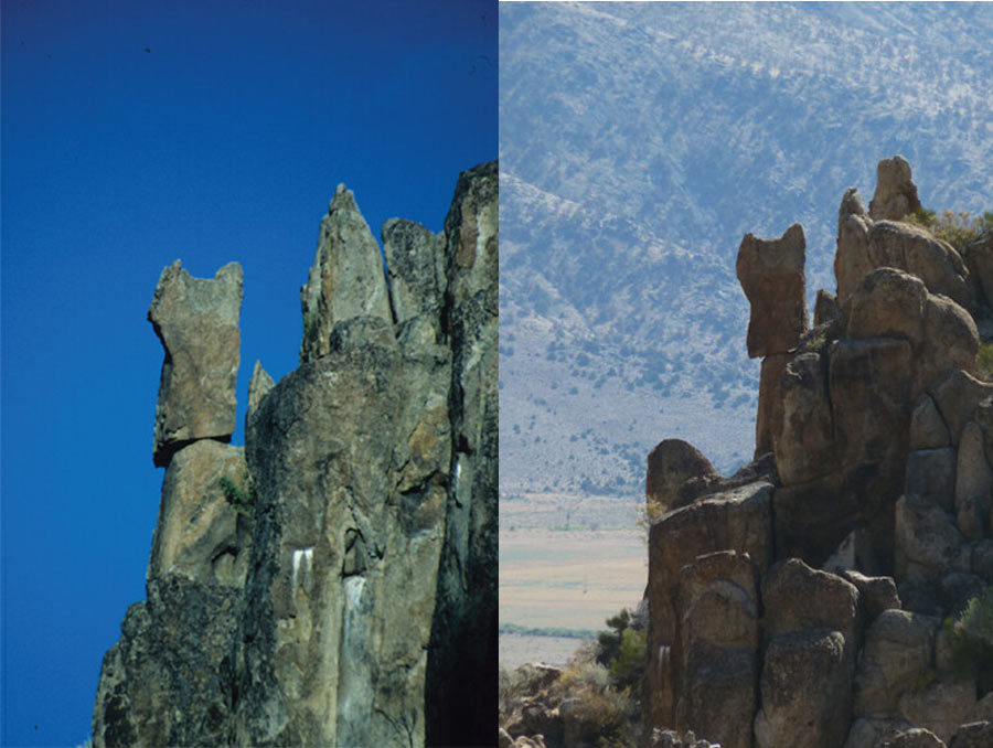
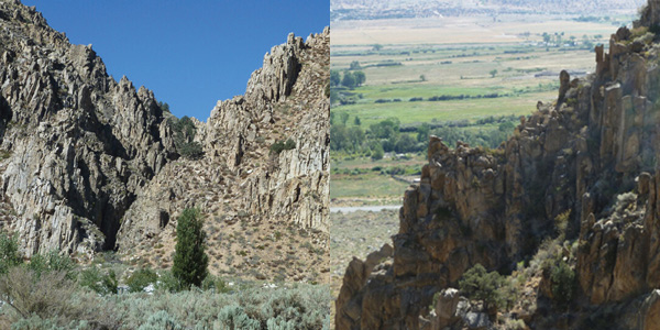
Approximately 80 miles south of Reno, just inside California’s eastern border with Nevada, three distinct, large rocks sit at the edges of cliffs, looking like they will topple over at any moment. These features, known to geologists as precariously balanced rocks, have been precarious in Antelope Valley for at least two decades and likely for thousands of years. Those rocks remain standing, despite a significant earthquake in 2021 shaking from an epicenter less than 4 miles from where the rocks are perched.
Daniel Trugman, an assistant professor in the Nevada Seismological Laboratory, is a seismologist who tracked down the precarious rocks after the 6.0 magnitude earthquake. He and his colleagues published a research article about the rocks and what they think allowed the rocks to stay upright after the earthquake.
One of the colleagues Trugman worked with is Jim Brune. Brune, an emeritus faculty member at the University, is like a celebrity among seismologists, Trugman said.
“His interest scientifically for, probably the past 25 years, has really been on these precarious rocks and how we can use them as long-lived seismometers to constrain earthquake hazards,” Trugman said.
Using precarious rocks to map earthquake hazards
Earthquakes can be devastating, so an understanding of where and when they might occur is important, but incredibly difficult to predict. Engineers, geologists, and seismologists collaborate to build seismic hazard maps, which help engineers understand the type of buildings that can or cannot be built in a given location, based on the risk of earthquakes.
What goes into building a geologic hazards map, though, is a complicated mix of variables. Where could the earthquake originate? What fault lines exist in the region? How might the earthquake propagate? How big could the earthquake get? What type of rock is in the area? How strong might the shaking be?
One of the challenges in determining earthquake risk is the lack of data. Researchers need thousands of years of data to have a complete catalog of large and damaging earthquakes.
“Really the only hope you have is from the geologic record,” Trugman said.
That’s where the precariously balanced rocks become useful.
“If you see a precarious rock that is still standing, that gives you some upper bound on the ground motion that could have been observed at that site over the lifetime of the rock,” Trugman said. “Jim’s idea was to use these precarious rocks as a way to test hazard maps.”
Brune began to identify precariously balanced rocks in Nevada and California in the 90s, including the rocks in Antelope Valley, and found that there were some significant flaws in the way that hazard maps were being made.
“[Jim found that] the rocks couldn’t all still be standing if the hazard maps were correct,” Trugman said.
That finding was validated, but with a twist, when the earthquake hit Antelope Valley in 2021.
Brune, who has been retired for years, wasn’t able to get to the field site through the rough terrain.
“You’re kind of scrambling around in these canyons to go find the rocks,” Trugman said. Trugman, who enjoys rock climbing, didn’t mind. “That’s something that I like to do anyways.”
Trugman made his way to the field sites, and much to his surprise, he found the rocks still standing. The classical models would predict that the rocks would have fallen, and that’s what Trugman expected to see.
“[Jim] was just as surprised as I was that the rocks were still standing,” Trugman said. “But if you do the math, it makes sense.”
Using precarious rocks complicates building of hazards maps
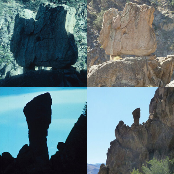
Building a geologic hazards map is complicated enough, but when using precariously balanced rocks as a data source, there are another series of questions that need to be addressed. How big are the precariously balanced rocks? Different sizes are beneficial, Trugman said, because then “you can start to play.” You can identify bounds. But it can be hard to find older, small rocks, which fall over more easily. Smaller rocks also look less distinctive and can be harder to identify.
To understand earthquakes in a region, it’s also important to try to understand how long a rock has been precariously balanced for.
“Depending on how the rock became precarious, that might be a very different answer than how old the rock itself is,” Trugman said.
On the east coast, the precariously balanced rocks were more likely to have been deposited by glacial activity. On the west coast, the rocks were more likely to have been established there by erosive processes. The erosive processes make the use of precariously balanced rocks in geologic hazards maps more complicated, because it’s hard to determine which erosive processes acted on the rock over millennia.
Another important consideration is how long the shaking from the earthquake lasted. This is known as pulse duration and is where the precariously balanced rocks in this particular study make for an informative and useful sample. As it turns out, the length of time the rocks are shaken for is important.
“Especially for these bigger precarious rocks, it’s not enough just to have a strong acceleration,” Trugman said. “You have to have a long enough pulse duration to push it over.”
The earthquake that struck Antelope Valley in 2021 was powerful, but because it was so close it had a short pulse duration at the precarious rock site. When the pulse duration is taken into account in testing a hazard map, the math checks out.
“The latest engineering models developed for this problem predict that all the small rocks should be knocked down, and all the big ones, like the ones that are in all the classic photos, should be standing,” Trugman said. “And that’s roughly what we found.”
The duration of shaking during past earthquakes is hard to determine if there isn’t a seismograph to measure it. Whether there is a long duration or short duration of shaking isn’t well-recorded in geologic history, except for precarious rocks.
“The paper is something of a validation of these more sophisticated engineering models of toppling, but it makes it a little bit more complicated to use the rocks to test hazard maps,” Trugman said. “It doesn't mean you can't use them, but it means you have to take into account both the strength of the ground motion and then also the pulse duration. And that's not something that's usually considered.”
The research findings make a compelling case for taking the precariously balanced rocks into consideration when building accurate hazard maps for building safety. Trugman wants to explore this idea more with precarious rocks in the Truckee Meadows.
Antelope Valley lies on Walker Lane, a series of faults. Walker Lane is a relatively active group of faults, with similarities to faults in the Reno area.
“The Mount Rose fault system could produce an earthquake similar to the Antelope Valley event or bigger tomorrow, and it wouldn’t be that unexpected,” Trugman said. “So this work has relevance for Reno in the sense that tectonically, the two locations are very similar.”
Some scientists have begun to use drones to create 3-dimensional images of precarious rocks and measure their properties to better understand how precarious the rocks actually are, which is something Trugman would like to explore in combination with better modeling of ground shaking. “There really are a lot of exciting science questions to explore in this field, and ones with profound societal impacts for communities like ours near active fault systems.”


