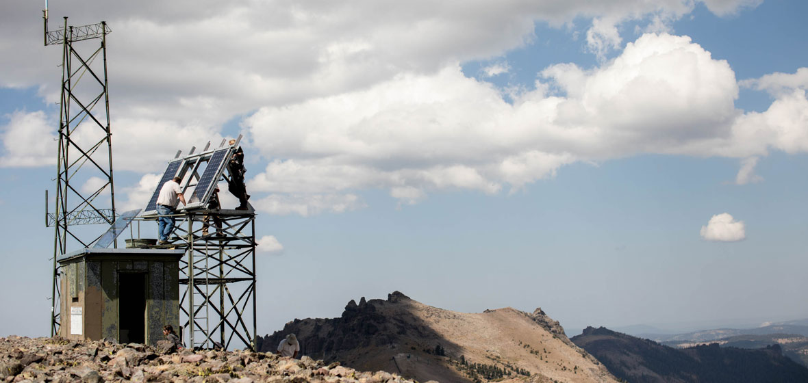
Just south of Lake Tahoe one sunny September morning, scientists and technicians carried a couple of hundred pounds of communications equipment to the top of the 9,700-foot Melissa Coray Peak, a couple of miles from the top of Kirkwood Mountain Resort.
The equipment, components for the AlertTahoe fire camera network's newest camera/communication site, was put to good use almost immediately as firefighters were able to track a re-ignition of the Donnell fire near Sonora Pass two days after the install was complete.
"It was quite a slog with an 80-pound pack on my back, but helicopters (the only other means of access) were busy fighting fires," Graham Kent, director of the AlertWildfire network and director of the Nevada Seismological Lab, said. "and it is well worth it with this super-high elevation peak that gives us a panoramic view of the Sierra, all the way to Yosemite."
The majority of the equipment was helicoptered to the site and the final portion of equipment was carried due to lack of helicopter access during installation.
The peak was first climbed in 1848 by Melissa Coray and the group of settlers she traveled with. Their wagon train pioneered a route through the area, earning the title for the highest elevation mountain crossing. It's still hard to get to even 170 years later, Kent said.
Tracking fires successfully since 2014
The nearly 30-camera AlertTahoe network tracked more than 100 fires for firefighters in 2017, and this new camera opens up even more coverage for the network that extends for hundreds of miles around the clear blue waters of Lake Tahoe in California and Nevada. One camera can see 5,000 square miles during the day; and from 11,000 square miles to 20,000 square miles at night using its near-infrared capabilities (on unobstructed view sheds).The system has been used successfully by firefighting managers for four fire seasons for early detection, to spot and track fires and for quicker, cheaper and more tactical response and suppression.
While Alert Tahoe has already successfully assisted with early detection of wildfires, it also played a critical role for early detection during an arson outbreak in late 2016 at South Lake Tahoe with some 30 fires in a 60-day period both in the City of South Lake Tahoe and the surrounding forests.
The fire-camera system is built on the backbone of the University of Nevada, Reno's Seismological Lab's earthquake monitoring communications network, which features private high-speed internet connectivity capable of transmitting seismic, environmental and climate data, in addition to the live-streaming high-definition video from the fire cameras.
Fire managers can manually rotate, tilt, pan and zoom the cameras. While fire agencies can move the cameras with this active pan-tilt-zoom functionality, the public can observe the real-time views, as well as the time-lapse functions with a 15-minute, 60-minute and 6-hour time-lapse utility built into the webpage viewer (right-click on the camera image for options). The Seismological Lab's YouTube channel, nvseismolab, has a library of videos captured from the network.
Kent leads the public-private partnership to ensure fire cameras are placed in strategic locations around the Lake Tahoe Basin. The AlertTahoe network is a collaboration with the U.S. Forest Service, the Tahoe Prosperity Center and the University of Nevada, Reno. This camera and installation was funded by the USFS El Dorado National Forest, and the Kirkwood Mountain Resort has been helping with access to the backcountry.
AlertWildfire Project
The AlertTahoe network is a part of the AlertWildfire project that includes networks in Napa/Sonoma, Nevada's Great Basin, Oregon, Idaho and parts of Southern California.
Kent and his crew have teamed with Neal Driscoll at U.C. San Diego and Doug Toomey at the University of Oregon in expanding the AlertWildfire networks.
Through partnerships, collaborations and outreach with fire agencies, landowners and community organizations to fund acquisition and installation of mountaintop high-definition camera systems, the University and it's partners have made great inroads to helping many agencies with fire response. They work with the BLM, U.S. Forest Service, Cal Fire, Nevada Division of Forestry, a dozen local fire protection districts as well as other agencies such as NOAA weather service, air pollution control districts, to name a few. Fundraising also comes from the public with the Tahoe Prosperity Center spearheading the fundraising efforts in and around the Tahoe Basin for the fire cameras.


