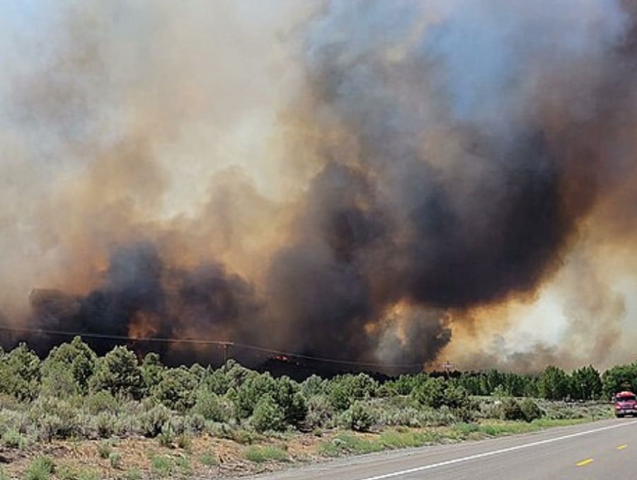
With a winter characterized by substantial precipitation and robust vegetation growth in the Great Basin, what are possible implications for the upcoming fire year?
On episode 13 of Extension’s Living With Fire Podcast, Christina Restaino, assistant professor at University of Nevada, Reno Extension, engaged in a discussion with Joe Smith, a research scientist at the University of Montana, and Jeremy Maestas from the USDA Natural Resources Conservation Service. The three discuss the connection between rain, snow and fire risk in the Great Basin.
Smith and Maestas are part of a team of researchers who have developed a new tool to predict wildfire probability in the Great Basin. This tool incorporates historical data and current conditions to provide fire probability maps, offering valuable insights for land managers in the region.
Discussing the natural wet and dry cycles that characterize the Great Basin, Maestas and Smith share their findings. Smith's research, based on 32 years of data, sheds light on the implications of these patterns for potential fires. Restaino chimes in adding what this means for Great Basin residents and how to take a proactive approach.
Resources:
• Great Basin rangeland fire probability tool
• A Homeowner’s Guide to Cheatgrass
• Be Careful! Cheatgrass is extremely flammable!
• Fire Adapted Communities: The Next Step in Wildfire Preparedness
Living With Fire - Ep. 13
On episode 13 of Extension’s Living With Fire Podcast, Christina Restaino, assistant professor at University of Nevada, Reno Extension, engaged in a discussion with Joe Smith, a research scientist at the University of Montana, and Jeremy Maestas from the USDA Natural Resources Conservation Service. The three discuss the connection between rain, snow and fire risk in the Great Basin.
Jeremy Maestas 0:00
All this water that came this year is going to have consequences for us possibly next year. Right because of all this growing vegetation production is going to build up out there and there's no amount of livestock and insects in the world that are going to eat it all. So it'll build up on the landscape and probably show up next year in the fire probability maps.
Megan Kay 0:29
This is the living with fire podcast, brought to you by the University of Nevada Reno extension. High their walk Welcome back to the living with fire podcast. I'm your host, Megan Kay, Outreach Coordinator for the living with FIRE program. And as I'm recording this in my basement in Reno, Nevada, it's raining outside a lot. Hopefully, you can hear that and hopefully my basement doesn't flood. But that's just indicative of this crazy wet and wild winter slash spring we've been having here in the Great Basin. And on this episode, we're going to learn what all of this precipitation means for the upcoming fire year. So you're not going to hear too much from me this episode, this conversation was facilitated by the director of the living with Fire Program. Christina was Donna. I'm Christina
Christina Restaino 1:17
Rossano. I'm on the faculty here at usr
Megan Kay 1:21
she spoke with Joe Smith.
Joe Smith 1:24
So my name is Joe Smith. I am a research scientist at the University of Montana,
Megan Kay 1:31
and Jeremy Maestas,
Jeremy Maestas 1:33
Hey everybody, Jeremy Maestas here with the USDA Natural Resources Conservation Service.
Megan Kay 1:39
So I'm just going to hand it off. And let's hear what Christina has to say about this episode.
Christina Restaino 1:43
I would just point out that, in this episode, we really tried to untangle the relationship between rain and snow. Right. So how much rain is snow that we get in a winter and what that means for the fire season coming up? And I think that all of us in the Great Basin region right now are really curious about what to expect this year, right? It's like, okay, we've had this big winner. We haven't had a lot of fire in the past couple years. We know that's related to the drought. So what does it mean when we get a lot of rain and snow? What does that mean for fire? So it's a fun conversation that kind of dives into that.
Let's get into the real meat of the discussion here. And really start to talk about what all of this precipitation in the Great Basin means when we're thinking about the fire year. So what do we expect to happen with fire in the Great Basin this year, after this big winner,
Jeremy Maestas 2:49
fire risk is not created equally across the landscape is where I would start in describing this. And so for listeners out there, who are probably familiar most with forests, and forest fires, there's always enough fuel in a forest to have a large fire, right. And so the scenario in which we have large fire years in forests is determined mostly by the amount of moisture in the vegetation. So things are really wet. They're not going to ignite and burn at larger scales, at least the likelihoods lower, okay. But remember that the nature of the Great Basin, most of it is not forested, it's actually shrub lands, grasslands open country. In in that scenario, what we call rains lands. Fire probability is determined more by the amount of fuel, vegetation build up a fuel, we don't have enough fuel every year to have large fires. So those are two different scenarios. And in that case, it takes time for grass enough grass to build up to have a large shrub land or grassland fire year. So Joe can unpack some of his work. I don't want to be a spoiler here, but we learned some really cool insights about what it takes to set us up for large fires. And maybe he can speak to that a little bit more here.
Joe Smith 4:29
Yeah, that's a perfect setup. You know, be thinking about that fuel limitation idea, you know? Yeah, how much how much fire is going to occur in a given year really depends on how much fuel is there but that's how much fuel is there is not just determined by what grew this year, or by what grew you know, in the spring Leading up to the, to the fire season. It's, it's determined by that plus carryover from previous years. So, you know, if a bunch of you have a really productive year, you're going to have a lot of sort of stand standing dead vegetation, and you're also just going to your, your perennial plants are just going to grow a lot because of that. So you're going to have bigger plants with more biomass. And not all of that is going to go away, you know, it's not all gonna get eaten by herbivores or compacted by snow, some of that's going to be there again next year. So you have this kind of this build up that happens across years. And actually, in the Great Basin, at least in most of the Great Basin, especially in Nevada. How much fire you get in a given year is actually more correlated with what happened last year than it is with what happens this spring. So, you know, for if we're thinking about this 2023 fire season even more important than what was this winter? Like? Or what's the spring? Like? You want to be thinking about what happened last, you know, May, June, July? The there's quite a bit higher correlation between those conditions in this upcoming fire season than there are between you know, what, what kind of a winter was it this this winter?
Jeremy Maestas 6:32
Yeah, it blows me away about Joe's work. Because it's pretty common to have a big wet year or a big dry winter and say, Boy, we're gonna have a heck of a fire year, this year, whatever. And that's true when it comes to forests. But it's not the same when it comes to these open grassland shrubland ecosystems that characterize most of the great bass. And so the big reveal in his work was like, it's really about what happened last year. And we now have the ability to quantify that and see it at large scales and say, Okay, well, have we really set ourselves up this year, based on what happened last year,
Christina Restaino 7:11
just to unpack all of this a little bit, right. So in a year, where there's been a lot of rain, and snow, we expect there to be more production of grasses and shrub land stools. So the vegetation itself will grow more. But what you're saying, Joe, is that in a year in which things actually grow more, it might take a year. And then it might be that next summer, we might expect there to be more fire in these ecosystems that just created a lot of plants and fish that eventually become fuels. Right? It's all those when when we talk about fuels in the forest world, we're not talking about gasoline and and in the fire world, right? In general, we're we're talking about sticks and grasses and shrubs on the ground. Sometimes we use that that word liberally and people don't understand for direct fuel. So so that are you saying, Joe, that that we might not expect this immediate summer to be a big fire year in the Great Basin, but maybe look out for next year?
Joe Smith 8:21
A great overview. And and I think that's exactly right. I think this this big, you know, this big winter, we're going to see the consequences of it, but we might not see it until next year. And I think another another aspect to think about besides besides just how much fuel is out there is, you know, how much how much of that fuel is dead versus alive? I think so this is kind of where this is where you can you can kind of think, okay, maybe, maybe this fuel conditioning issue does matter a little bit for rangelands, but you just have to think about it a little bit differently than you do in forest. So in a year, like a year like this, you know, we didn't have a lot of growth last year, we've been climbing, you know, the Great Basin has been climbing its way out of a drought that peaked in about the summer of 2021. And so we didn't have a lot of growth in 2021. We didn't have a lot of growth in 2022. We're getting that growth now. We're getting that that fuels accumulation now. But in this summer, a lot of the fuel a lot a large proportion of the fuel that's out there is going to be green stuff that grew this year. So I think there's there is a little bit of a an element of you know, the fuel condition matters. And I think that when you have when you have a larger proportion of the fuel that's dead, you know, that's that standing dead that that carried over from past yours I think that's really a recipe for, you know, a volatile fire year.
Megan Kay 10:06
Let's take a quick break
I wanted to take a quick break to talk about the living with Fire Program. Maybe you found this podcast and you're wondering what is the living with FIRE program? Well, we've been around since 1997. We're managed by the University of Nevada Reno extension. And we're really a collaborative effort amongst federal, state and local firefighting agencies, as well as resource management agencies to help people adapt, prepare and live more safely with wildfire. So if you haven't already, check out our website living with feiyr.com, where you'll find all of our resources and tools that will help you with more safely with wildfire. Okay, back to the show.
Christina Restaino 10:56
Good time, I think for one of you to just define what the Great Basin is
Jeremy Maestas 11:03
the Great Basin hydrologically is where it's like the Hotel California of water, rain and snow that falls in the Great Basin stays in the Great Basin, it never leaves. And so we have a series of mountain ranges across the region that run generally north south. And in between all of those ranges, we have these big open valleys where all the water that comes off the mountains goes into the valleys and evaporates in essentially terminal lakes. So instead of flowing out to the ocean, water generally just stays within this big region that we call the Great Basin centered, really on top of Nevada, but spanning parts of Utah, Idaho, Oregon, and in California.
Joe Smith 11:53
I think like like any of these polygons that we put on maps, it has fuzzy edges, and those where those edges fall depends on who you ask. And so there's the kind of hydrologic gray base and wherever you everything is inwardly draining and that's that's kind of a common, common understanding. But then there's also I think for AI if you ask more of a plant ecologist or a wildlife biologist, they'd probably give you more of a plant based definition. So the the sort of unique thing about the the western portion of it is just how dominated it is by by wintertime precipitation. So when you get into the the other, you know the sagebrush ecosystems more on the other side of the Continental Divide your mud and much more of a summer precepts. system. And so the the Great Basin, when I think of the Great Basin, I kind of think of it a little bit broader than then just the hydrologic, Great Basin my extended up into, you know, further into southern Idaho and parts of Oregon that don't really fit that, that in order that we draining hydrologic definition intersect. Yeah, I would
Jeremy Maestas 13:09
add that it's it's like Joe's saying, really arid, and you know climatically extreme, we're in the winter, we get, we can get really cold and a lot of snow. But in the summer, it's super hot and dry. And so those extremes drive, the limited amount of production we get in terms of vegetation in the region, and it's made it really a tough place to live and settle. And the evidence of that is like if you go on Google Earth at night, you ever seen that map with like the lights at night, it'd be one of the darkest places left in North America. And that's why we like living in it. Yes, exactly.
Christina Restaino 13:53
I see really good stars for my backyard. Joe, I'm curious you work in in the space of predicting the probability of what of what the probability of fire will be for the fire season. And I've looked at the fire probability map for this year, and it is higher than last year. So let's talk a little bit about that. And why is it higher than last year and then kind of dive in a little bit of you know, who uses those maps? How do you make them things like that? But I'm just curious, because even though we're we didn't have a lot of growth last year, and we're, we're, why is it expected that we might have a little bit of an elevated probability of fire this year?
Joe Smith 14:43
Yeah. So I mean, the short answer is that it's a little higher this year because you can't really get any lower than it was last year. You know, 2020 21, like I said earlier was the depths of that. out. That was that was about the worst that God said, Really, at least in sort of, you know, recent memory. Last, you know, decade or so 2021 was really one of the lowest production years that there was, that's why 2022 is just so exceptionally you know, those probabilities were, were exceptionally low across most of the great base. And so, you know, we've been sort of climbing our way out, you know, I wouldn't say that we're completely out of out of the drought yet. But we've been climbing our way out. And so it's just, it's, it's going to be rising, those I would expect, actually, the next year is even going to be higher, just because of what's happened this winter. So yeah, that's that's kind of the the short version. That
Christina Restaino 16:03
makes sense, though. And I think that helps people understand, it certainly helps me understand because I think that, you know, we have to understand like the baseline probability of fire is always going to be a certain amount in the Great Basin, right? This is a fire prone landscape. And so it's, it's interesting that we've, we've been in kind of the lowest probability of fire for the past few years because of this big drought, right. And so now we're expecting all of this new growth, which is going to increase the fire risk. But it's also going to bring all you know, it's a balance, because it's also going to bring more forage to the range lands, more productivity, recharging of the groundwater, it's also going to bring with it some flooding and some fire risks of sites, these, these these balances of how these, you know, climatic variations, kind of influenced the day to day of life in the Great Basin. I don't know if you want to comment on that. Jeremy, before we move on to talking about these maps a little bit more?
Jeremy Maestas 17:09
Yeah, the variability in conditions out there is a defining characteristic of the Great Basin, as we talked about earlier, wild fluctuations between year to year terms of how much moisture we get, how the vegetation responds. And, of course, the wildlife populations, the people that have been on these landscapes, they're all following those patterns are of boom and bust. And so if you look at the maps that Joe produced, because he was able to leverage, you know, 30 years of, of satellite imagery, were able to go back in time and kind of see that year to year variation. So in any given year, the patterns of large fire risks really are aren't the same. But there are some observations maybe we can dive into here, more in terms of like, the northern Great Basin, right when you get up along the Snake River plain, Eastern Oregon, and a Winnemucca, Nevada north, you know, that area, more years than not tends to have a higher probability of large fires. And some of that goes back to what Joe was talking about in terms of grass and find fuels. And the build above that is more often happening in that part of the Great Basin, as opposed to Southern Nevada, where it's a rare, exceptional year where you're gonna get enough production to really have a huge fire being likely
Megan Kay 18:47
just take a quick break.
Wildfire is stressful, and wildfire, evacuations are stressful. That's why the living fire program is created our wildfire evacuation checklist. It's a really simple checklist to help you learn how to pack a go bag, and prepare your home in your family, even your pets for wildfire evacuation. I've included the checklist in the links in the show notes below. So be sure to check that out. You can also find it on our website at living with feiyr.com.
Christina Restaino 19:26
So, Joe, you make these wildfire probability maps and we've alluded to them quite a bit. But let's get down to kind of what goes into making these and why are they necessary to make?
Joe Smith 19:40
Yeah, so these these maps are really sort of designed to fit into a unique gap in the existing fire risk products that are already out there. There's there's a lot of fire danger products that have been produced. Things like the National Fire Danger Rating System. And then there's also things there's there's products that that look at fire risk over over a really long, long time periods. Right? What we produced was a product that kind of looks at, you know, what's, what's the what's the fire risk for the upcoming fire season. So it's this internet intermediate timescale between products like the National Fire Danger Rating System, which tell you about like, what's the fire risk in the next like, 48 hours to maybe a week. And then those longer term products on the other side, so we're kind of trying to fit it right in the middle there. So that's, I guess, that's sort of the context for for these products that we developed. And the other I guess, the other important context is sort of the technology side of things. You know, until very recently, we just didn't have high resolution data on vegetation production. That was dynamic. So we could say something about what was produced in an average year. But we didn't, we didn't have a dynamic product that told us, you know, okay, what was produced last year? Was it above average, or was it below average? Now we have our our models use data from the range land analysis platform, so that that product gives us annually, percent cover and an estimate of production in pounds per acre, for every 30 meter pixel of range lands across the whole west. So that gives us sort of a the missing missing link of fuel amount that that you'd actually need to make these sort of annual longer range forecasts for the great bass. And so what we're basically doing is combining the cover vegetation cover and production data, that's an annual timestep from from the Rangeline analysis platform, with some drought metrics and precipitation metrics, from some gridded meteorological datasets, and then we're, you know, combining combining those as machine learning models to try to predict what the what the conditions are, like, how ripe is it, you know, for a fire at a given given location? So that's, that's kind of the gist of the models and what what they do. So we release them, we can we can make a prediction or a forecast for the upcoming fire season, starting in about in a typical year, starting in about February, and then we can update that throughout the spring. Who,
Christina Restaino 23:04
who uses the maps? Like, how is the data ultimately, right? Because it's this kind of this complicated distillation of a lot of different data, you've got the vegetation data, you've got the climate data, you use models to bring it all together? And then kind of how is it applied and used? Yeah,
Jeremy Maestas 23:25
the maps are especially beneficial to like those federal land management agencies like the Bureau of Land Management, or Forest Service, that are stewards of a great portion of the region just because of the public land ownership there. So you have some of our larger local BLM, fire and fuel staff, who are starting to look at this product alongside those traditional metrics that Joe mentioned, like the National Fire Danger Rating System, and other indicators so that they can improve their preparedness going into the fire season. So throughout the fire season, they're running around their district trying to assess fire conditions and imagine that challenge of communicating what's going on across your area when for example, you are responsible for Harney County, Oregon, which is six and a half million acres in size, one county. Okay. And so historically, they're using climate and weather data and other Predictive Services that can provide some coarse estimates. They're using their local knowledge and some field sampling of vegetation. For the first time with Joe's product, we've got a real time forecast of vegetation conditions across every single acre in their district. And it's dynamic so you can see it change across the district is not all uniformly distributed. There's parts of it, that might be higher probability of a fire than others. And so they can use that information to inform things like resource allocation. Where are we going to put our firefighters our dozers? How much do we need to ask for this year in our district? Do we need to talk about closures to the public in certain areas a certain time of the year just because what we know is likely to happen. And so the public might encounter those things. But have the agencies have the data to better support the rationale for why they do that.
Joe Smith 25:40
It's, you know, firefighters, the the fire suppression community is really they are reacting in real time to conditions on the ground, you know, they are really going to be looking at things like temperature and wind speed and humidity. Those are like the big things that drive the decision making process. And during firefighting, it's not how much you know how much cheatgrass grew there last year or whatever, like that's, that plays a role in what happens during a fire. But the big the biggest drivers are weather. So this is this is really, I think this this product is really aimed more toward managers who can do something about management before a fire starts is really about pre fire management rather than the actual act of firefighting itself.
Jeremy Maestas 26:35
You know, one point that scientists have has put out there in the last couple of years is that more acres of these range land ecosystems are burning than forested ecosystems across the US across the West. And that's especially true since about 2000. So, when we set national policy when it comes to fire management, it's usually around forest fire. But, you know, when you have more acres being burned on our grasslands, and shrublands. Today, I think there's a growing awareness that we need to allocate more resources towards that to help affected communities and in the region. And, you know, this type of work can help bring those resources to the Great Basin in a timely fashion to ensure that, you know, we, we enhance the effectiveness of our firefighting community, to beyond where it's at today, which is really high, like something like 97% of all fires that start in the Great Basin are put out before they become more than 1000 acres in size. So we're already hyper effective fire suppression. But the reality is that that 3% That gets away from us are getting really big.
Megan Kay 28:00
Let's take a quick break.
I hope you're enjoying the episodes so far. Just wanted to quickly let you know that these wildfire probability maps for the Great Basin that we've been discussing. They're available online, and we included a link to the maps in the show notes below. So when you get a chance, go check them out. Okay, back to the show.
Christina Restaino 28:32
Jeremy, you were just discussing how, you know, in the past two to two decades, I think you said so the past 20 years, you know, we've experienced most of our largest range land fires, what's changing in the Great Basin that is making these kind of uncharacteristic large fires occur?
Jeremy Maestas 28:54
Yeah, you know, I always like to caveat our fire discussions by saying fire is not neither bad nor good. It It just is. It's a part of this system. But the reality is that it's not 1850 anymore in the Great Basin. By that I mean before a European settlement where we brought livestock and invasive species and all these other changes to the system. So today, when we have fire, we have plants from other continents, invasive species, invasive annual grasses in particular, like cheatgrass that are waiting in the wings to take over and replace the perennial native vegetation that characterizes the great bass. So historically, large fire years in the Great Basin happened, but they were more rare, infrequent and driven by that accumulation of our perennial native perennial grasses, bunch of grasses that are out there on the landscape and when we got enough of that built up enough dead material across the landscape, we'd have a big fire here. What we see today and we look at Joe's data, he actually mapped this out for us looking back, you know over the last 30 years is that we fluctuate in our perennial grass production from year to year. And that's largely stayed fairly stable in terms of the amount of of grass production coming from our native native grasses. What's changed though, is that cheatgrass and other invasive grasses, have been slowly increasing over that 30 year period such that the amount of above ground production or grass biomass that's out there, in some years can exceed the amount of our native grasses today. So in 2016, I think that was the first year that we documented that happening, we had more grass production come from invasive species than than our native grasses. Why does that matter? It means that those years in which were set up to have enough fuel to have large fires are becoming more and more frequent, because of invaders, like cheatgrass that have filled in the what used to be like bare soil interspaces, in a more of a desert environment, right, we didn't have anything growing there, essentially. Now you put this other plants in the middle, and it creates a very continuous grass fuel bed that allows those fires to become really large. And that problem is largely what we think is driving some of the patterns that we're observing in terms of larger, more frequent fires, especially in the northern part of the great face.
Christina Restaino 31:52
After these years where we've seen a lot of rain like and snow like we had this year, would we expect more cheatgrass to grow?
Jeremy Maestas 32:00
So we should see really good cheap grass production, unfortunately, because higher moisture this year,
Christina Restaino 32:09
and so Joe, is the cheat grass production taken into account in the probability maps that you guys create?
Joe Smith 32:16
So yes, and no, it actually turned out that that information didn't really add a whole lot in terms of how well the models worked. So for right now, anyway, we're just relying on last year and the year before. But future iterations of this might might use a bit more information about current years, kind of spring gross,
Christina Restaino 32:45
that it does take into account. Yeah, but it does take into account last year in the year before she crashed scruff, like that. Plant is part of what you're seeing in the models.
Jeremy Maestas 32:55
Yeah, like what Joe mentioned earlier in the podcast, all this water that came this year is going to have consequences for us possibly next year. Right? Because all this growing vegetation production is going to build up out there. And there's no amount of livestock and insects in the world that are going to eat it all. So it'll build up on the landscape and probably show up next year in the fire probability maps. And the
Christina Restaino 33:21
year after using two years. Yeah, so it could be a legacy that's kind of you know, to me, the moral of the story here is that, really, there's a priming that has to occur for to get that big fire year in the Great Basin, right, where it's like, you have to have that big winner, and then the productive spring and summer, and then fast forward a year or two. And so if we have a really big drought next year, that could really set it up even more because we've had all this growth and then everything will dry out. Right. So it's that combination of production of grass, and shrubs, and woody biomass in general combined with you know, what are the current conditions existing on on the landscape when a fire could be ignited? Right. So it's like that combination of the two. So like anything in the Great Basin, the story is complicated. But
Joe Smith 34:19
yeah, yeah, that's a pretty good description. Actually, the the wet dry cycles in the Great Basin are pretty regular. And that's when we you know, we should be really worried as when we're coming out of a wet cycle into the into the dry portion of the cycle.
Christina Restaino 34:37
So to me, I would think the call to action as a resident in the Great Basin is to spend this summer doing some really good defensible space action around my home and collaborating with my community and kind of taking this time to prepare, anticipating that next year will be will want to be on guard for what could happen in the sagebrush ecosystems around our committee. It is what a
Jeremy Maestas 35:01
perfect tee up Christina because that's where my head was going like, you know, the upshot of this work is that we can forecast with with a great degree of accuracy, the probability of large fire, we now know that it's not just driven by woody vegetation, which is often the focus of fuel management. But in these range land or shrub Land Systems, it's grassy fuels that drive large fire. So if you're a community, you talk about defensible space. In addition to the woody fuels management you might do around your infrastructure and your roads so that people can safely fight fires, you need to think about grass. So if you're doing mowing alongside of roads, and you mow the brush off, so that your flame lengths aren't too high, but then all you do is open it up for cheatgrass to explode. That's something we'd ask you to consider managing to. So maybe some integrated treatments where we use herbicides to actually kill that invasive annual grass. So we don't have that herbaceous production alongside of our roads or infrastructure that, you know, might serve as a source of ignition source. We're doing this on larger scales with landowners and in the public land management agencies, you know, to implement things like targeted grazing, where we focus livestock grazing in huge pastures to try to break up the the amount of grass fuels that build up over the landscape. So those are definitely things that this year people should be thinking about, especially in those regions on Joe's map that are kind of in that upper moderate to high elevated probability of fire. So remember, grass fuels drive these large fires, so it's not just about managing your shrubs and trees.
Megan Kay 37:09
Thank you for listening to the living fire podcast. You can find more stories and resources about wildfire at our website living with fire.com The living with FIRE program is funded by the Bureau of Land Management, the Nevada Division of Forestry and the US Forest Service and were managed by the University of Nevada Reno extension, an equal opportunity institution.


