Associate Professor in the Department of Geography Steph McAfee serves as Nevada’s State Climatologist. She recently published an update about Nevada’s drought, which was shared through the Living With Drought program and is published below. Living with Drought is a collaborative program that provides information to help Nevadans prepare for, respond to and recover from drought.
Temperatures are starting to rise and are expected to stay hot throughout the summer. Most of Nevada's reservoirs are at or above their usual capacity for this time of year.
Current drought conditions in Nevada and across the West
After a cool and generally wet June, most of northern Nevada is now not only drought-free, it is not even D0-Abnormally Dry. Drought is still hanging on in far southern Nevada, with D2-Severe Drought in Clark County and D1-Moderate Drought extending into central Nye County and western Lincoln County. However, more than half of the state is now free of drought or dry conditions. This is the first time that has been true since February 2020. It's also a significant improvement from this time last year, when over 99% of the state was in at least D2-Severe Drought, and there was still some D4-Exceptional Drought.
One-class improvements were made across Nevada, southeastern Oregon, and across the Plains regions of the West. In the Pacific Northwest, drier-than-normal June weather triggered degradations, leading to drought development and exacerbation. Drought also persists in northwestern Montana, across the Idaho panhandle and in far southeastern New Mexico.
Although much of the West is getting a reprieve from drought, there is significant drought in the central US, with D3-Extreme and D4-Exceptional Drought stretching from South Dakota to Kansas and east into Missouri and Iowa.
June temperature, precipitation and snowpack
June was cooler than normal statewide. Temperatures were anywhere from 1°F to more than 5°F below normal. The far northwestern part of the state was relatively warm, with temperatures near or only slightly below normal. Southern and eastern parts of the state were much, much cooler than normal. Harry Reid International Airport in Las Vegas reported only three days with above-normal high temperatures this June. The Westwide Drought Tracker indicates some small areas, mostly in Nye and White Pine counties, where this June was, at least provisionally, the coldest since 1895.
Across much of the state, June was also relatively wet, delivering 110% to more than 300% of normal precipitation. June is quite dry in many places, so it might still not be a huge amount of rain. For example, the Desert National Wildlife Refuge, northwest of Las Vegas, received 0.61" of rain over two days in mid-June. Normal June precipitation at that station is 0.06". The National Weather Service Office received 0.26" of rain, when it usually receives 0.02" in June.
As of late June, parts of the Sierra still boasted a substantial snowpack. The Mt. Rose Ski Area had almost 20" of water in the snowpack, a little less than in 2017. Leavitt Lake in Mono County still had about 70" of water remaining in the snowpack. While not record-breaking (2017 and 1995 were snowier in June), it is a lot more snow water than the usual couple of inches.
Soil moisture
Despite relatively heavy rainfall in Mineral, Esmeralda, and parts of Clark counties, both top and subsoils in the region remained dry according to SMAP. Further north and across much of eastern Nevada, soils were generally wetter than normal. The Climate Prediction Center indicates that soil moisture is wetter than normal across the entire state. Unfortunately, this kind of disagreement about soil moisture is not uncommon. We have relatively few direct observations, which means we rely on remote sensing and/or models, which are useful but imperfect tools.
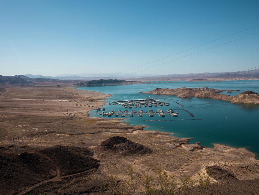
Water resources
Nevada reservoirs are in generally good condition statewide. Many reservoirs are at or above their usual late-June capacity. Bridgeport Reservoir and Topaz Lake are less full than normal, but this is likely a choice to avoid flooding, given the near-record amounts of water still in the Walker Basin snowpack. Lake Mead levels have been rising steadily since spring, and forecasts suggest that will continue at least through summer. Under the most likely scenario, Lake Mead would remain in shortage, but reservoir levels are in much better shape than anticipated at this time last year.
Perhaps unsurprisingly, most stream gages reported higher than usual flows in June, though, as always, management does influence flows on many of Nevada's rivers and streams.
Looking forward
There is still not a strong signal for a wet or dry summer. Across essentially all of Nevada, there are equal chances that summer will be dry, near normal or wet. Summer is expected to be drier than usual in the core monsoon areas of Arizona and New Mexico.
Summer is expected to be hot—there are 50 - 60% chances that temperatures will be higher than normal across most of the state. The first week in July was certainly consistent with the seasonal outlook. Temperatures exceeded 110°F at some southern Nevada weather stations and approached 100°F in parts of northern Nevada.
Courtesy of the very wet winter, drought is not expected to develop in northern Nevada. On the other hand, drought in southern Nevada is not expected to resolve. The generally spotty precipitation expected in summer, coupled with high temperatures and accordingly rapid evaporation of available water, makes it unlikely that soils will wet up or streams and reservoirs fill much further.
High soil and vegetation moistures, as well as a decent high-elevation snowpack, mean that significant wildfires are less likely than normal at higher elevations. Fire risk in the Sierra Nevada remains lower than normal through September. At lower elevations, however, wet conditions allowed relatively lush growth of grasses and shrubs that can dry out quickly when storms taper off and temperatures rise. As a result, the risk of significant wildfires is higher than normal in southeastern Nevada during June and in northwestern Nevada in August and September. Even lower-than-normal risk does not mean no risk, and there have been several mostly small fires already this season, so remember to consult Nevada Fire Info for fire activity, restrictions, and fire prevention tips.


