With a big spool of fiber optic cable and a large suitcase-size laser generator, College of Science Professor Scott Tyler travels the globe taking the world's temperature. He's dropped a temperature-sensing cable through Antarctic ice to the ocean bottom to measure the temperature and gauge the melting of the ice sheets. His wonder-cable has been to Switzerland to study glaciers, to Germany to study coal mine reclamation and acid mine drainage; to study the dynamics of salt marshes in the San Francisco Bay; and studying water temperature at Devils Hole in Death Valley to help protect the endangered Devils Hole Pupfish.
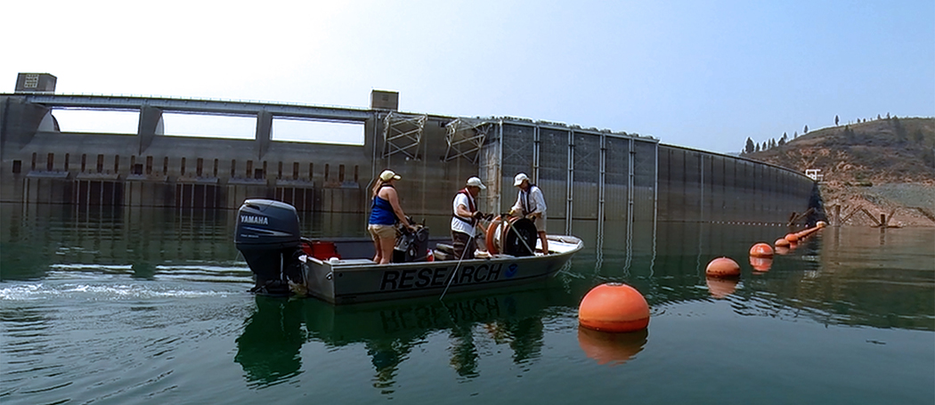
Just last month hydrologist Tyler set up a system to measure the water temperature at drought-stricken Shasta Lake in northern California to help water managers release the proper temperature water to keep the endangered Chinook salmon alive.
Tyler is responsible for an integral element of the NOAA salmon protection project: 1.usa.gov/1LiiGj0 [t.co], measuring the temperature of the water continuously every few centimeters from the surface of the lake to the lake bottom.
His distributed-temperature-sensing system, which uses light-scattering as it passes through an optical fiber, is used around the world on a variety of critical projects that require getting accurate and continuous temperatures, 24/7. In this case his data will be used to keep salmon alive. The equipment uses a laser to send and receive certain wavelengths along the glass fiber, which is about the diameter of a human hair. The amount of travel time in the cable allows Tyler to determine temperature at various intervals by the wavelengths that return. It's called distributed temperature sensing.
"At the heart of the new system is a fiber optic cable from the National Science Foundation's CTEMPs instrument facility at the University of Nevada, Reno," project manager from the NOAA said.
Tyler is co-director of CTEMPs, the National Science Foundation Center for Transformative Environmental Monitoring Programs, based in the University's College of Science, in a collaboration with Oregon State University.
"With much of the salmon spawning run in crisis, the flows are critical to ensuring a successful fish spawning run," Tyler said. The cable system stretches a half-mile and drops 400 feet to the lake bottom in a looping configuration. The old system used by the Bureau of Reclamation gave a temperature reading every two weeks, this system is set to give readings every four hours.
"This is a proof-of-concept project this year, through the winter, then we can build a more permanent system," Tyler said. "The data we are already receiving is beautiful; we can see every small change as they release water from the dam."
The use of this technology was pioneered by Tyler in 2008 to first study soil temperature and other soil characteristics along the Walker River near Yerington. The system uses a standard issue fiber optic cable similar to that used to transmit telephone and data to your house, in innovative ways to study a wide variety of hydrological, climatological and geological topics in Nevada and around the world.
Research on seven continents
Through work on all seven continents and over landscapes ranging from the Dead Sea to Antarctica, more than 60 projects, from as many academic institutions, using CTEMPs services and equipment have studied oceanic, atmospheric, geologic and hydrologic systems. This research led to the publication of more than 27 peer-reviewed papers in 2014 alone.
"This technology is like no other in that we can measure temperature along many points (high spatial resolution) at once and record it over a long duration at each of those points."
For example, Tyler and his crew rolled out 700 meters of cable in the headwaters of the Great Basin National Park's Strawberry Creek.
"It's a small rugged headwater creek where the park service wants to re-introduce Bonneville Cutthroat Trout, the native species," Tyler said. "The creek has a small flow rate and the park service wanted to see if the low flows would be warm enough to support the trout population before planting the native fish.
On another project a few years ago at Lake Tahoe, Tyler hung three cables 1,500 feet to the lake bottom. He gathered temperatures from every meter of depth. Scientists watched the fluctuating temperatures at the 100-foot level, the bottom of the "warm" water, as every 20 minutes an underwater wave sloshed back and forth across the 72-mile circumference lake while the surface water was smooth and flat. Seeing the patterns of water movement and temperature layers helps researchers understand nutrient movement at the interface of the warm and cold water, he said.
Tyler's excitement for these projects and the new technology is still strong, as evidenced by his work with NOAA Fisheries and the Bureau of Reclamation on the Sacramento River and Shasta Dam.
"We spent several days laying out cable in Shasta Lake and bringing the system online," Tyler said. "It's great to get out in the field and customize a new system to gather important environmental data, data that can make a difference."
With that project well underway, in October he hopped a plane to a remote region of Mongolia to work with University colleagues to study the world's largest trout - which can grow up to six feet long. He'll oversee a new technology in his environmental monitoring arsenal, aerial robots (quadcopters), to track the big fish.
UAVs in Mongolia
CTEMPs has traditionally deployed the fiber optic-based temperature monitoring systems to researchers' sites across the United States and around the world, and now, with $2.2 million in new NSF funding, the Center will do the same with the aerial robots, also know as unmanned aerial systems or UAS. The environmental monitoring center is now also the NSF's center for AirCTEMPs, which will provide the equipment, training and maintenance of the aircraft - just as they do for the DTS systems - so researchers aren't burdened by the operational aspects of their high-tech tools and can focus on their science. AirCTEMPs was recently featured as the cover story of EOS, the American Geophysical Union's weekly science magazine; reaching more than 50,000 earth scientists.
The project in Mongolia is designed to gather data about fish population to be used in evaluating a proposed dam upriver from their habitat. Tyler partnered with College of Science colleagues Sudeep Chandra and Zeb Hogan from the Department of Biology, who have been studying this river for a decade. The team also included College of Engineering faculty and pilot Warren Rapp, from the University's Nevada Advanced Autonomous Systems Innovation Center, to complete the collaboration.
"We were successful in showing this technology can be used in a new way," Tyler said. "We spotted a huge Taimen on a flyover, as well as other fish. The pictures were clear, the project was a great success."
This landlocked salmon has been documented to reach nearly 200 pounds, and is now only found in a handful of rivers in Mongolia and Russia. A proposed dam on the Eg River has scientists worried that this drastic change to the fragile ecosystem may have devastating effects on the Taimen's ability to survive and reproduce.
Up until now, mainly traditional methods have been used to gather and document fish populations. Limited tracking of the Taimen is being done through radio tags placed on fish after they are caught and then released.
The inclusion of this technology, the aerial robots, is meant to enhance the data-gathering process to better quantify the fish population of the river. In the pilot study, Tyler and the team were able to spot fish from about 15 meters above the water using the small quadcopter equipped with a video camera.
"It was wonderful to have the freedom to fly as needed, with no height restrictions," Rapp said. He piloted the UAS around the remote research encampment on a bluff overlooking the river. "My biggest concern was not dropping the aircraft into the cold water and watching it sink and head downstream never to be seen again. The vehicle performed amazingly and the video was spectacular."
NAASIC partners with CTEMPs to provide the UAS expertise. In 2013 the states of Oregon and Nevada were designated by the FAA as national UAS test sites, making it easier for researchers to integrate the new technology into their studies. NASSIC is an important collaboration for this new direction, bringing expertise in a number of areas.
"Combined with the expertise from our partners at Oregon, NAASIC will provide aerial sensing of land surface topography, temperature and vegetation health for agriculture and forestry with resolution on the ground of a few centimeters; far better than traditional helicopter or fixed wing aircraft." Tyler said. "And we can do it at one-tenth the cost and with far less risk to flight personal or people on the ground. We are already seeing a huge interest in using UASs for environmental monitoring. It's very satisfying to see CTEMPs become a huge success."


