A graduate student in the Environmental Sciences Interdisciplinary Graduate Program recently started work on a program that will measure the campus’ buildings, parking lots and sidewalks effects on the natural water cycle. Jessie Henning, a 25-year-old Ohio native, is studying how the disruptions in that cycle as a result of campus buildings or parking lots as well heavy precipitation sometimes lead to flooding at the Truckee River.
“The goal is two-fold,” said John Sagebiel, environmental affairs manager in the University's Environmental Health and Safety department and Henning’s project advisor. “One is trying to assess where we are now and to get a handle on what the campus’ impact in respect to storm water is. And second is to produce what I would best describe as planning tools.”
The project is aimed at studying how the campus affected the storm water drainage in the past and how it is affecting it now. A second part of the project includes creating a planning resource that can outline how future structures will affect the drainage.
The role of impervious surfaces
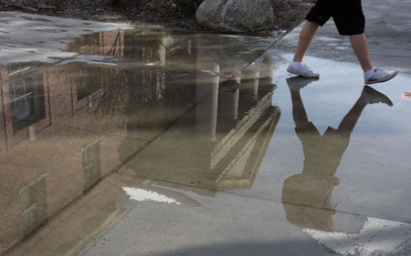
A natural part of the hydrological water cycle occurs when precipitation, as a result of snow melt, rain or a combination of both, is soaked into the soil and becomes ground water or eventually drains into the river at a slow rate.
Because of man-made, impervious surfaces like asphalt or buildings, storm water drainage systems have been developed to drain the runoff into the Truckee River. When an excess amount of water is being drained into the Truckee River instead of being soaked into the ground or taking the natural amount of time to get to the river, flooding occurs.
As a downriver land owner, the University hopes to benefit from studying how impervious surfaces on campus affect that system. In January 2006, flooding damaged University property at the College of Agriculture, Biotechnology and Natural Resources Main Station in East Reno and resulted in livestock losses.
“It’s not just being a good citizen of the community,” Sagebiel said. “As an added benefit we’re trying to help protect our own property from being flooded.”
Long-term effects
One of Henning’s goals is to shed awareness on how natural cycles are being affected. Henning also recognizes the importance of this study in a broader and a long-term perspective.
“In light of climate change, we’re supposed to get more precipitation events and with that we’d get more increased run off,” Henning said. “We need to be aware of that and start developing ways to keep that water local to where we can recharge ground water or use it for irrigation needs. It’s going to become more of a scarce commodity as global climate change furthers.”
Henning is also developing a map that can be used as a tool in campus and construction planning for lessening the campus’ contribution to the disruption of the cycle and to flash flooding. This geographic information system (or GIS) map can simulate how the buildings affect water runoff, how much water is being used, as well as how other surfaces are taking in the water.
“What the goal always is that when you change the natural environment, when you build new buildings or plan new things, you always want to keep that regime [the water cycle] close to the predevelopment runoff rates,” Henning said.
At the moment, Henning is compiling data to for the GIS map and narrowing down the research methods she will be using.
“I think I’m in the meat of it,” Henning said. “I’ve learned so much just by reading.”
Henning is receiving funds from the University's environmental health and safety department and the Academy for the Environment. Sagebiel recognizes the University community’s effort in understanding its environmental impact.
“It’s something that was one of those ongoing issues we needed to address or should be looking at,” Sagebiel said. “Now all of a sudden we got an opportunity with the right person and we can now do a really good assessment.
