The Sierra Nevada mountain range boasts some of the best rock climbing, clearest alpine lakes, and most epic ski terrain in the world. But the story of the Sierra Nevada goes far beyond humanity’s short time on Earth, and for over a century, scientists have been researching the history of the mountain range. By publishing a research article on the topic, a former doctoral student and her advisor have just waded into one of the great controversies in geology.
Scott McCoy, the Peter Vardy Endowed Professor in Geologic Engineering, commonly studies surface process hazards like floods, landslides and postfire debris flows. But he also researches how these processes shape landscapes over millions of years. His former doctoral student, Helen Beeson (Ph.D. Geology '19), studied how rivers, and the basins that contain them, change over time. Their recently published paper puts them at the center of the debate regarding the evolution of the Sierra.
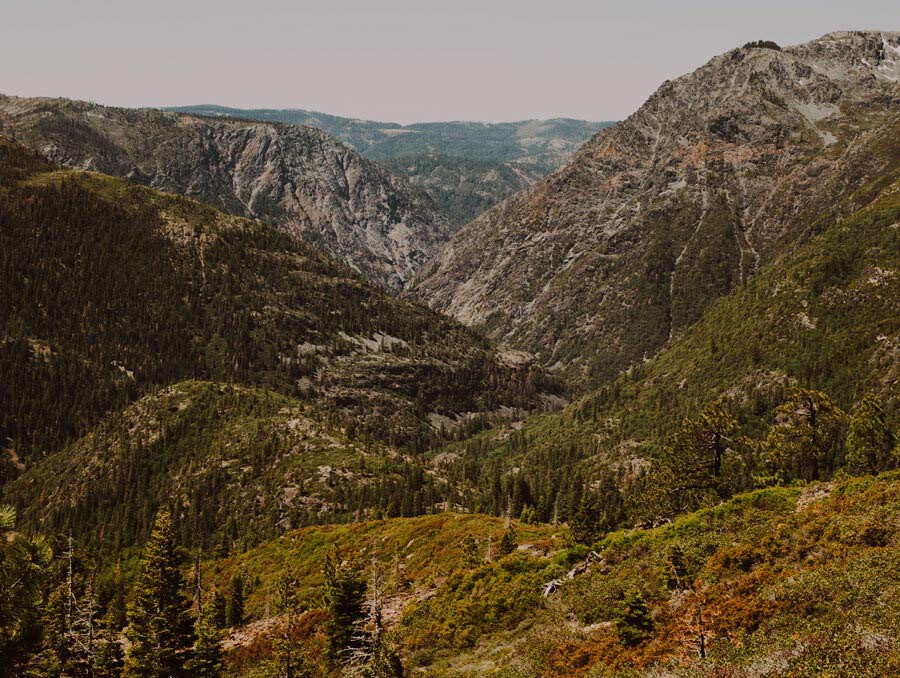
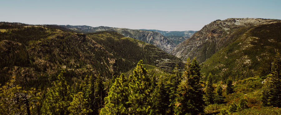
“The Sierra has seen an incredible amount of study for hundreds of years,” McCoy said. “Early mappers were fascinated by this mountain range because it’s an odd one. It has a precipitous eastern slope that drops steeply down to towns like Reno and Bishop, but a long western slope that gently approaches the lowlands around the Central Valley towns of Sacramento and Fresno. Gentle, that is, all except the canyons that cut deeply into the western slope. From the first day western people started recording observations, there was a controversy of how the range reached the current state.” The question at hand is whether the Sierra Nevada are young (geologically speaking) or old. And the rivers on the western slope of the Sierra hold the answer.
The debate
Science has advanced so that researchers now know much more than they did a hundred years ago. But the question still prevails.
“The controversy continues today in a slightly more nuanced way of saying there are lots of mechanisms that might have brought this mountain range high, but many of them are very, very old. There was unquestionably a big mountain range there for a long time,” McCoy said. The debate is more about what happened to that mountain range in the past 50 million years.
We went into this research for another reason. We didn’t want to get into the tectonic controversy.
Shifting tectonic plates form mountain ranges, but over millions of years, those mountains can be torn down again by precipitation, rivers and glaciers.
“From the shape of river landscapes, you can read landscape history,” McCoy said. He said the story written in the rivers on the west side of the Sierra says there has been recent, if not active, tectonic activity that uplift ed the mountain range to its current high elevations. A river that has long adjusted to the prevailing climate and tectonics will get less steep as the river progresses down the mountain. The landscape will also have a gentle slope. But the western side of the Sierra has a gently sloping landscape with steep river canyons. Those river canyons have unusual steep sections called "knickpoints" that indicate the river is still actively changing its slope and adjusting to its landscape.
Some geologists who think the Sierra has long been high propose that eroded material and rocks from volcanic activity in the ancient Sierra built up the range and attribute the deep, knickpoint-ridden river canyons to recent climate change. A few million years ago, Earth’s climate cooled and then began to oscillate, building large masses of flowing ice to form glaciers during colder periods and then melting them away during warmer periods. They propose this unstable climate and runoff from glaciers led to rivers cutting deeply into the sides of the Sierra. A few million years is still recent in geologic time, so the apparent newness of the rivers can be explained in the “old” camp by climate inciting rivers to incise through the sediments that buried previously deep and ancient canyons.
The “young” camp challenges that idea, because 50 million years is a long time for such a tall mountain range to stick around without being torn down by erosion. “Additionally, the deep canyons slicing up the western side of the Sierra cut well below the level of the younger sediments from erosion and volcanic eruptions and are deeply incised into what geologists call the hard rock basement of the range,” McCoy said. “Deep incision into basement rock can only occur if those rocks have been brought above sea level by tectonic uplift.” The “young” camp proposes there are young tectonic processes that acted on the mountains in the last five or ten million years to incite rivers to cut deep canyons. "It is these young tectonic processes that brought the mountains to their current stunningly high elevation, including Mt. Whitney, the tallest in the contiguous United States," McCoy said.
The (original) question
“We went into this research for another reason. We didn’t want to get into the tectonic controversy,” McCoy said. He and Beeson wanted to look at how river basins changed in the West.

“In Reno, we’re sitting in the middle of an old river network where the headwaters used to be about a hundred miles to our east. Then we had Basin and Range extension that shredded this through-going river network into the closed basins that we live in now with terminal lakes like Pyramid Lake. Basin and Range tectonics broke it all up and sliced this ancient river into chunks with the western slope of the Sierra being the last and largest remaining chunk,” McCoy said. He and Beeson expected that much of what they saw in the rivers on the western slope of the Sierra could be explained by Basin and Range extension and the associated deposition of volcanics on the western slope.
“We had a good theory for how the rivers would respond, but we didn’t see any of the expected response at all. The shape of the rivers were fundamentally different from what we’d predicted,” McCoy said.
The new question
If the rivers on the western slope of the Sierra have changed so much and it wasn’t a result of the Basin and Range extension, what changed them? The knickpoints of the rivers seemed to be consistent along the Sierra Nevada, showing that there may be some other force at play in the mountains. Beeson used topographic analysis tools to look at river profiles – the elevation of a river from the headwaters to the mountain front – of all rivers on the western slope of the Sierra.
“The whole range seemed to be listening to the same forcing,” McCoy said. Beeson compared her analysis of rivers on the west slope of the Sierra with analyses from a simple model that took tectonic changes and the sudden slicing of the river into account. She found the model that best matched what was happening in the rivers. That model indicated that there was recent tilting of the mountains, steepening the western slope. “We saw this overprinting of young tectonics and found ourselves in the midst of this controversy,” McCoy said.
“It’s been a good lesson for really looking at the data, seeing what the data say and having an open mind,” Beeson said.
The complexities
“The Sierra are a total mess,” McCoy said. There is a lot of variability in the rock types in the range, making even simple models complicated.
“Rivers listen to everything. They listen to climate, how much rain they’re getting, they listen to the rocks they’re trying to erode away, they listen to how their basins are getting crushed or filled with volcanics. Our task was trying to see through that mess to the tectonic signal that appeared to dominate,” McCoy said.
One of the biggest challenges in interpreting tectonics from the landscape in the Sierra is that there is extreme spatial variability in the depth of river canyons. The North Fork American River, for example, cut the Royal Gorge to over 4000 feet deep, whereas right next door in the South Fork American River, parts of its canyon are less than 1000 feet deep.
“That isn’t typical for the way a young tectonic landscape looks,” Beeson said. “One reason for that is that the tectonics in the Sierra are nonuniform. Rather than the landscape being pushed up evenly, in the Sierra we see more of a rotation or tilt – there’s greater uplift closer to the crest with almost nothing at the mountain front. A second reason is that the rock types are really heterogenous in the Northern Sierra. There are some rocks like the granites that are really hard, and there are some metamorphic rocks that are really easy to erode.”
“By acknowledging that complexity,” McCoy said, “Helen was able to show that the reason there are large variations between rivers, or even branches of the same river, is because the rock types are different and each river has had a slightly different history of drainage area loss and gain.” Those losses and gains are due to the Basin and Range tectonics at play, during which each river got a different part of its headwater cut off. Analyzing large amounts of data has become easier and more accurate over the decades with improved technology.
“This paper was definitely built on other work,” Beeson said. “It was easy for me to do that because we live in an era where I can download all the digitized geology maps and digitized elevation data. I have the tools to recreate a lot of work that was arduous to do in the past.”
By accounting for the different rock types throughout the range, Beeson was able to analyze the entire range systematically to come up with a clear conclusion.
The answer
“In the end, we come down really strongly saying that when we look at the rivers on the western side of the Sierra, it reveals a very young (within the last five to ten million years) tectonic perturbation,” McCoy said. McCoy acknowledges that the Sierra was largely shaped by their ancient history, too. “In many ways our conclusion reconciles observations of both camps. The broad and gentle upland of the western Sierra are remnants of an ancient landscape, whereas the high crest elevations and the deep and recent incision that is working its way up through the river network can be attributed to young tectonics.”
“It’s exciting that we can reconcile these differences in previous work,” Beeson said. “I think part of why our work is cool is that we can say, ‘We’re in agreement with you.’ It is an old range newly dissected by recently invigorated rivers. It is glaciation, it is rock types, it is tectonics – we see all of these things.” Beeson’s work takes into account a variety of influencing factors.
“We had three rounds of extremely critical reviews, and while it was hard and a really painful process and took a lot longer than I wanted it to, the paper is much better for it and the evidence is much more solid,” Beeson said.
McCoy said that geology struggles with weak constraints. It’s difficult to state exactly when something happened when their timescale is in the tens or hundreds of millions of years, and that’s made more difficult by the “messiness” of the Sierra.
It’s kind of magical to think about things in geologic time because it’s so ineffable. Can anyone really comprehend what 10 million years is?
“I’m proud of what we did and I do feel like it’s pretty thorough. It doesn’t have to be right, I don’t have to be right, the conclusions don’t have to be the absolute truth, but we have interpreted the data we saw with the information we have now,” Beeson said.
“Thorough” is an appropriate term for the 40-page paper. “It seemed like each piece was important,” McCoy said. “It was a heroic amount of work.”
Speaking on science
The history of geology in America is deeply intertwined with colonial history. Oftentimes, early western geologists were surveying Indigenous lands to facilitate western expansion, be it for settlers’ farms or for railroads. “It’s a tricky place for our field as we strive to decolonize our science, in that large foundational pieces of our field were built by geologists surveying land to steal it from Indigenous people,” McCoy said.
And the field faces other challenges, too. When the paper was published, Beeson was nervous.
“It’s a contentious issue that a lot of people have worked hard on and consequently feel strongly about,” Beeson said. “While critical reviews can be constructive, we dealt with a level of hostile criticism that was beyond what other people we talked to had ever experienced. The person’s behavior was supported by the journal editors, so it’s hard to not see it as gatekeeping by senior white male geologists.”
But the science still thrills Beeson.
“It’s kind of magical to think about things in geologic time because it’s so ineffable. Can anyone really comprehend what 10 million years is?”


